

-

Overview & Formation TVLA is an Executive Agency under Tanzania’s Ministry of Livestock and Fisheries, formed by the merging of several legacy institutions—namely: Central Veterinary Laboratory (CVL), Tsetse & Trypanosomiasis Research Institute (TTRI), Tsetse & Trypanosomiasis Research Centre (TTRC), and multiple Veterinary Investigation Centres (VICs). The agency was officially established by government gazette (GN No. 74)…
-

General Overview Type & Ownership: NARCO is a fully state‑owned parastatal under the Ministry of Livestock & Fisheries, focused on large-scale commercial cattle ranching. Establishment: Originally created under the Companies Act in 1975, evolving from pre-independence operations like the Overseas Food Corporation and Tanganyika Agricultural Corporation. Headquarters: Based at the Nane Nane Exhibition Grounds, Nzuguni,…
-

Overview & Curriculum Co‑educational day school for ages 2–18, located in Mbezi Beach (Africana Junction), Dar es Salaam. Early Years (2–5): play‑based learning. Primary & Lower Secondary (KS1–3): Internationalised National Curriculum of England. Key Stage 4 (Years 10–11): Cambridge IGCSE. Sixth Form (Years 12–13): choice of A‑Levels, BTEC Level 3, or a blend—preparing students for university abroad. ✅…
-
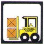
Background & Ownership State-owned enterprise: Wholly owned by the Government of Zambia through the Industrial Development Corporation (IDC). History: Traces origins to 2001 (formerly MOFED Tanzania Limited); over 40 years of operations in freight forwarding and logistics. 🌍 Regional Footprint Main hubs: Head office: Mukuba Depot near Dar es Salaam port, Tanzania. Inland Container Depots…
-
Location & Geography Region: One of six districts in Tanzania’s Morogoro Region, located in the southeastern part of the country. Bordering areas: Bordered by Kilombero District to the north and west, Lindi Region (east), and Ruvuma Region (south). Size & Topography: Covers around 15,751 km² (or ~10,689 km² by some sources), featuring low‑lying floodplains of the Kilombero–Ulanga…
-
Geography & Location Located in eastern Tanzania at the foothills of the Uluguru Mountains, about 196 km west of Dar es Salaam. Covers approximately 260–288 km², with elevations ranging from 500 m to over 800 m near the hills . Climate is tropical savannah (Aw) featuring bimodal rainfall—short rains Nov–Jan, long rains Mar–May—and average temperatures from ~16 °C to ~33 °C….
-
Location & Coverage Karagwe District in northwestern Tanzania covers around 5,134 km², bordering Uganda and Rwanda via the Kagera River, with a varied landscape of hills (1,200–1,800 m elevation), swamps, valleys, and small lakes like Burigi and Rwakajunju. 🌐 Administration & Governance It operates under the Ministry of Regional Administration and Local Government, led by the District…
-
Geographic & Administrative Profile Location: One of the seven districts in Kilimanjaro Region, northeastern Tanzania. It spans approximately 1,217 km², encompassing altitudes from lowlands up to Mount Kilimanjaro’s western slopes, including the Shira Plateau and the Klute Peak (3,952 m). District Capital: Sanya Juu. Wards: As of 2012 there were 12 wards: Biriri, Gararagua, Naeny, Karansi, Kashashi,…
-
Historical Background The original Njombe District Council was created in 1962, dissolved in July 1972, then re-established in 1984 following the Decentralization Act. In 2012, the old Njombe District was subsumed into the newly formed Njombe Region, which now comprises several councils: Njombe Rural (District), Njombe Urban (Town Council), Wanging’ombe District, plus Makete, Ludewa, and…
-

Overview & History Type & Location: Public university situated in southern Tanzania’s city of Mbeya, with campuses in Mbeya and Rukwa. Origins: Founded as Mbeya Technical College in 1986; became Mbeya Institute of Science and Technology (2005); finally elevated to a university in 2012–13. Leadership: Chancellor: Prof. Mark Mwandosya Vice-Chancellor: Aloyce (Aloys) Mvuma Academic Structure…